BIG STORM FOR THE WEST
BIG STORM FOR THE WEST
From opensnow.com
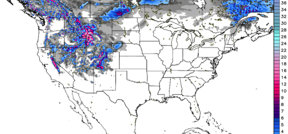
A cold storm brought snowfall to British Columbia, Washington, and Oregon over the weekend, and will now shift its focus to California, Wyoming, Utah, Montana, and Colorado during the upcoming week.
This will be the first major snowfall of the season for most of these mountain areas, and since this storm is packing cold temperatures, snow levels should drop down to the bases of most mountains. All of this is great news!
The map above shows projected snow totals for the next five days, and the timing will favor California, Wyoming, and Montana on Monday andTuesday, with more snow for Utah and Colorado later in the week.
Head on over to our forecast page to find an update from your local forecaster or a specific snow prediction for your favorite mountain.
Details
Watching and waiting for these slow-moving, cut-off storms is like the scene in Austin Powers where he is screaming for the steam roller to stop as the steam roller is moving toward him at about 1mph. In short, we are spending a long time in the anticipation phase.
The anticipation will last about two more days. As of Monday morning, the heaviest precipitation associated with the storm is falling in California (they need it!), Nevada, and southern Idaho.
Source: Weathertap.com
Ever so slowly, the storm and its associated precipitation will push to the south and east. Before it reaches Colorado, the heaviest precipitation on Monday and Tuesday will stay to our west, over parts of California, Nevada, Utah, Idaho, Wyoming, and Montana. Out ahead of the storm, look for windy afternoons in Colorado on Monday and Tuesday with gusts across the western part of the state reaching 30-40+ mph.
Unfortunately, the storm is going to split on Tuesday, with one part of its energy moving north and east over northwestern Wyoming and into Montana. Another part of its energy will hang over the southwest and then move over Colorado between about Tuesday night and Thursday.
This second piece of energy will provide the snow for Colorado, with snow levels starting high on Tuesday night into Wednesday (9,000-10,000ft), then dropping down to most valley bottoms by Thursday.
We should see a brief break in the snow on Thursday night, then a quick-moving storm from the northwest could provide a few more inches of snow to the northern and central mountains on Friday into Saturday.
Most of the midweek snowfall will occur with winds from the southwest, so the southern mountains and west-central mountains will be favored with the heaviest precipitation. Winds will switch to blow from the northwest on Thursday, Friday, and Saturday, and this is when the northern mountains will be favored.
The map below shows the total precipitation forecast through Saturday. Multiply by about 12 to estimate snowfall. This is from the Canadian model, though the American GFS and European models are similar in terms of the placement of the heavier precipitation. I would watch for the northeastern mountains (along the divide, west of Denver metro) to potentially have more precipitation than shown in this map.
Source: Weatherbell.com
Most likely we’ll see dry (but chilly) weather from Saturday midday or afternoon right through Monday, and then another cold storm should head toward Colorado early next week, around Tuesday November 10th, plus or minus a day.
If you’re planning for early-season powder, there will be some on Wednesday, Thursday, and likely next Tuesday or Wednesday.
JOEL GRATZ


